Nishi Family › Compare › Civic Quality-of-Life Map
Nishi Compare · capabilities, evidence and delivery
Civic Quality-of-Life Map
Compare capabilities and delivery evidence. Source discovery, qualification, deployment and accepted outcomes are separate; an open contract names work still to verify.
The Nishi sovereign US map of quality of life and land truth -- own geo stack over ODbL and public-domain data, judged layers, abstention over suppression, a partnership ranker and owner-attested listings -- vs PolicyMap and USAFacts and Zillow and Regrid and Google Maps Platform, Aug-2026 field
Overview
The purpose, declared position and evidence coverage of this domain. Source presence and completed acceptance are different measures.
Where we are. MEASURED 2026-08-27: the sovereign geo substrate is REAL and gated -- 23 GEO libs (web-mercator tiles, raster choropleth fill, spatial join, integer Dijkstra routing plus isochrones, geocoding, fuzzy places, hex indexing, GPS map-matching) plus a real-OSM vector renderer (nx_geo_osmrender: ODbL extract to a styled layered map, zero third-party map libs) and a measured-exceed geo census vs the Google-PostGIS-Turf field (gc_measure, ratchets as rungs land). What does NOT exist: any civic data layer, any US-wide banked base data beyond one test extract, any QoL index, any partnership ranker. The listings JUDGES live in realestate (fr_ev_present manipulation gate, cf_kv downside gate) and are repointed, never restated; nx_flip_gate ran GREEN 23 of 23 live at admission.
Where we need to go. OPERATOR ASK (2026-08-27): identify potholes, power outages, crashes, cancer counts with the downwind-of-nuclear-testing lens, taxes, transportation cost -- bottom-up and top-down -- find where to PARTNER WITH GOVERNMENTS to improve citizens' lives across jobs, agriculture and industry, all on a Nishi map forked off maps that exist, with land and buildings for sale (especially by owner) and an answer to the fake-dollars-per-acre gaming on Zillow-class platforms. Strategy: LAYERS ARE DATA ADMISSIONS (source, licence, resolution, cadence as rows, refused without a mirror), the map is EMITTED native output with no third-party JS receiving our work, suppression and absence ABSTAIN and never read as zero, and every composite index decomposes into named signal rows.
Research bar. PolicyMap layer catalog, the civic-data-mapping practice bar is measured on the incumbent's breadth of admitted layers over a web map sold to governments and universities. Theirs: the field's working answer to civic data on a map [policymap]. Ours: CM9 done means the board publishes its own layer census beside the incumbent catalog -- and the exceed is honesty: every Nishi cell that cannot be observed renders UNOBSERVABLE, never zero.
Research bar. EAGLE-I, the outage-history bar is measured on ORNL's county-level 15-minute historic outage record, the only national public outage history. Theirs: coverage varies by state and year and no licence is stated on the landing pages [eaglei]. Ours: CM6 done means county outage-hours render with the modeled-coverage bound printed beside every figure and the licence question resolved at admission.
Research bar. Suppression honesty, the small-count bar is measured on the peer-reviewed finding that county counts under ten are suppressed and ignoring that censoring understates rural mortality. Theirs: the reason a suppressed cell must abstain [wondersup]. Ours: CM8 done means a suppressed cell that renders as a number is a gate RED -- abstention is enforced, not advised.
Research bar. Sales truth ground rules, the anti-gaming bar is measured on eleven states never publish sale prices, so recorded-sale ground truth is structurally impossible there [@ndstates]. Theirs: the honest boundary of any dollars-per-acre ruler. Ours: CM15 done means an out-of-distribution listing claim carries a NAMED evidence flag through the manipulation gate and a non-disclosure state prints UNPROVABLE, never a guess.
Business case
| Axis | Position | Figures | Decision |
|---|---|---|---|
| Investment | every layer is free public data, public domain or ODbL; the spend is organ work, not subscriptions | 23 u to a national QoL map with zero data contracts | commercial parcel and listing feeds (Regrid, ATTOM-class) are BUY decisions priced only when a paying use appears |
| Market | bottom-up: citizens and buyers get an honest map -- the dollars-per-acre refusal is the story the listings incumbents cannot tell; top-down: the partnership board turns measured need plus mirrored funding into a concrete government pitch | one closed government partnership pays for the program | the compare surface publishes the whole thing as receipts |
| Partner motion | cm_need_rank output IS the pitch: county X has need Y measured, funding Z exists mirrored, capability W is live -- the meeting artifact is generated, never written | governments get evidence, not slideware | composes the alignbiz census and the supply-chain case math (sc_domestic_permil) for the jobs and industry story |
| Zillow counter | we never host a manipulated listing: owner-attested intake, recorded-sale truth, named-evidence flags; non-disclosure states abstain | honesty as the moat -- a listings surface whose refusal record is public | realestate RE6-RE7 carry the ruler; civicmap renders it |
Latest recorded release
No valid dated release entry is recorded for this domain.
Release entries describe recorded changes; they do not establish that every capability passed evaluation.
15 of 27 capability source symbols found|4 of them authored stronger-claims|12 open|coverage 555/1000|adoption 7 full / 8 partial
Evidence profile — what the gaps on this board actually are
Measured by nx_swcompare_evidence, read back by nx_evprofile_lib. Every figure is a count with its denominator — there is deliberately no score, no grade and no percentage anywhere in this band, because a stored scalar is a field a seat can edit and a counted partition is not.
evidence|grounded 15/15|unsupported 0|gates green 1/1|proven able to fail 0/1|never bitten 1|green at 0/0 0|open gaps 12|of them unnamed 0|of them proof withheld 0|flips ready 0
proven able to fail counts the gates that have a RECORDED RED — nx_gate_bite mutated the gate subject, rebuilt it, watched the gate go red, and that record is inside the shared TTL. never bitten is its complement over the same denominator: those gates ran and were green, and nothing has ever shown them able to detect anything, so their green is a statement about this run and not about the gate. green at 0/0 is a separate and much weaker observation — the gate printed GREEN on a zero denominator, so its own tooth counter says it examined nothing. A gate can be green, non-zero, and still never bitten; that is the common case and it is now visible instead of implied.
partition: grounded + unsupported = 15 vs present 15 · named + unnamed + withheld = 12 vs open 12 · both reconcile
liar-kill conj=GPQN · all four conjuncts held
graded document: BUILDROOT tree, 15614 bytes · gates map: PRIMARY · stamped 1d 1h ago · source ../knowledge/status/evstamp_civicmap.verdict
| Gap class | What it is, and the work it names |
|---|---|
| NONE | No gap class fires on this board: every published claim is grounded, the declared gates ran and were green, no watch contract is unnamed or already landed, and the stamp is inside its TTL. That is a statement about evidence, not about depth, scale or polish. |
nx_swcompare_evidence civicmap itself and are not carried on the stamp, so this page names the classes and the producer names the rows. That split is stated rather than hidden: a count without a worklist is not actionable, and this band is honest about which half of that it is.Production map
Follow the dependencies, declared acceptance criteria and recorded priorities. Inspect source binding before treating a rank as executable work.
Ranking source binding: STALE_OR_INVALID_BINDING. Recorded priorities require current acceptance evidence and resource checks before execution.
Recorded ranking withheld
Retained ranking is not bound to the current plan and matrix: STALE_OR_INVALID_BINDING. Historical data remains retained. Refresh the ranking after resolving the input differences. Latest execution outcome is unverified.
Declared roadmap — contract, acceptance, executor, effort
| Rung | Closes with | Definition of done (pre-declared) | Executor | Est. |
|---|---|---|---|---|
| Layer admission, data-driven (CM1) | cm_layer_admit | a layer is source-url-licence-resolution-cadence ROWS; refuses without licence and mirror; a bad layer gets better data, never removal | Organ | 1.5 u |
| Point-to-county FIPS join (CM2) after CM1 | cm_fips_join | LANDED 2026-08-27: geo_spatial_join assigns any lat-lon row to its county, DISCRIMINATES between counties, and reports a point in none as OUTSIDE COVERAGE rather than zero; proven by nx_civicmap_gate T11-T13 plus a raster second method | Organ | 1.5 u |
| US county base BANKED: public-domain TIGER polygons (CM17) after CM2 | cm_tiger_bank | SPLIT FROM CM2 2026-08-27 because the join landed and the bank did not, and one rung claiming both would have read as national coverage. The full county set banked and pinned, the partition summing to the county count and printing it | Data | 1.5 u |
| County choropleth emit, native (CM3) after CM2 | cm_choropleth_emit | composes geo_raster and mapsvg; produced-work attribution printed on the page; zero third-party JS | Organ | 1 u |
| First layer live: bridges or fatal crashes (CM4) after CM3 | cm_crash | NBI or FARS bulk mirrored and pinned, county rollup, page live with per-layer freshness stamp | Organ | 1 u |
| 311 and pothole intake (CM5) after CM3 | cm_open311 | Open311 plus city bulk portals; per-city coverage printed; the NYC 2020-rescope gotcha handled by dataset identity not URL [nyc311] | Organ | 1.5 u |
| Power outage layer (CM6) after CM3 | cm_outage | EAGLE-I county-hour history mirrored with the coverage bound printed beside every figure; ODIN rides beside it for the live view | Organ | 1.5 u |
| Road and bridge condition (CM7) after CM3 | cm_roads | HPMS roughness and NBI condition ratings as separate admitted layers [roads_trimble] [roads_vialytics] [roads_michelin_exit] [roads_rdd2022] [roads_uav2024] [roads_ecu2026] [roads_uas2026] [roads_ocp2024] | Organ | 1 u |
| Cancer layer with suppression honesty (CM8) after CM3 | cm_cancer | county rates from the mirrored public record; a suppressed cell is UNOBSERVABLE, never zero; registry coverage printed | Organ | 2 u |
| Taxes, transport cost, jobs, agriculture (CM9) after CM3 | cm_tax_jobs | government-finance, ACS, BEA and agriculture admissions each with their own cadence; transport cost DERIVED from public sources because the incumbent index forbids redistribution [hntlic] | Organ | 2 u |
| Downwind overlay (CM10) after CM8 | cm_fallout | fallout-dose geography rendered beside the cancer layer; the page prints correlation-is-not-causation and cites the epidemiology | Organ | 1.5 u |
| QoL index, decomposable (CM11) after CM4 | cm_qol_index | a county score is a sum of NAMED signal rows and always decomposes; a missing axis ABSTAINS and the denominator prints beside the score | Organ | 1.5 u |
| Partnership opportunity ranker (CM12) after CM11 | cm_need_rank | measured need x live funding (SAM.gov, Grants.gov, USASpending mirrors) x live capability; every rank prints its grounds; composes the civic-axes spend contract, never a second spend ruler | Organ | 2 u |
| Parcel layer (CM13) after CM3 | cm_parcel_layer | renders realestate's re_parcel_intake counties; free statewide parcel programs first; per-county coverage printed | Organ | 1 u |
| FSBO owner-direct intake (CM14) after CM13 | cm_fsbo_intake | owner-submitted listings only, never scraped; acreage and price pre-filled and checked against the address and parcel record at intake; feeds the map and the realestate judges | Organ | 1.5 u |
| Dollars-per-acre truth layer (CM15) after CM13 | cm_acre_truth | recorded-transfer distribution per county in disclosure states; an out-of-distribution listing claim is flagged with named evidence through the manipulation gate; non-disclosure states print UNPROVABLE | Organ | 1.5 u |
| Environment layers: water and air (CM16) after CM3 | cm_env | drinking-water violations by county and service area plus validated air data, each admitted with its lag and join geography printed | Organ | 1 u |
Milestones
| Milestone | Rungs | Cumulative |
|---|---|---|
| M0 · One honest layer on a real map | CM1,CM2,CM3,CM4 | 5 u |
| M1 · The QoL board | CM5,CM6,CM7,CM8,CM9,CM16 | 14 u |
| M2 · Downwind proof and the index | CM10,CM11 | 17 u |
| M3 · Partnership engine | CM12 | 19 u |
| M4 · Land truth on the map | CM13,CM14,CM15 | 23 u |
| Class | Count | Note |
|---|---|---|
| bars | 0 | sotabar rows on the plan |
| fresh | 0 | the bar month is the current month |
| attested | 0 | an older bar with a this-month barscan reporting no newer entry |
| stale | 0 | a this-month scan saw a newer month the bar ignores |
| unattested | 0 | nobody looked this month |
| malformed | 0 | a sotabar row missing a field |
| duplicate | 0 | bar ids an earlier row already carries |
| bars, summed | 0 | RECONCILED: the parts sum to the total 0 |
| current month | 2026-10 | the month every bar is judged against |
Inspect a rung and its prerequisites
Declared nodes 17. Rank input binding: STALE_OR_INVALID_BINDING. Dependency order is authored. Implementation, acceptance evidence, authority and resource readiness are unverified. No action is recommended or dispatched here.
Plan SHA-256 a61b51691e3f9266697c0e69e2a09dd15f9edd85bbf54428c63f152682c71c63. Target rows 0; role rows 0. Existing risks and release worklog retain their own scope; no node completion is inferred.
Runtime observation coverage: 0 of 17 rungs have current, identity-bound execution observations. Observation may report RED. Accepted completion remains unknown; source presence, qualification and deployment do not establish it.
Use Enter or Space on a rung to inspect its contract. Prerequisite links locate another rung in this list; open its summary to inspect it. Estimates are authored effort, not forecasts.
CM1 — Layer admission, data-driven
Prerequisites: None declared; this does not establish execution eligibility.
Contract:
cm_layer_admitAcceptance: a layer is source-url-licence-resolution-cadence ROWS; refuses without licence and mirror; a bad layer gets better data, never removal
Authored effort: 1.5. Executor kind: Organ. Responsible, accountable and verifier not established. Inspect retained worklog.
Runtime observation: UNKNOWN; outcome UNKNOWN; observed epoch -1. Declared owner: . Receipt
, SHA-256. Identity-bound observation is not accepted completion. Qualification and deployment remain unverified by this projection.CM2 — Point-to-county FIPS join
Prerequisites: CM1 (acceptance unverified)
Contract:
cm_fips_joinAcceptance: LANDED 2026-08-27: geo_spatial_join assigns any lat-lon row to its county, DISCRIMINATES between counties, and reports a point in none as OUTSIDE COVERAGE rather than zero; proven by nx_civicmap_gate T11-T13 plus a raster second method
Authored effort: 1.5. Executor kind: Organ. Responsible, accountable and verifier not established. Inspect retained worklog.
Runtime observation: UNKNOWN; outcome UNKNOWN; observed epoch -1. Declared owner: . Receipt
, SHA-256. Identity-bound observation is not accepted completion. Qualification and deployment remain unverified by this projection.CM17 — US county base BANKED: public-domain TIGER polygons
Prerequisites: CM2 (acceptance unverified)
Contract:
cm_tiger_bankAcceptance: SPLIT FROM CM2 2026-08-27 because the join landed and the bank did not, and one rung claiming both would have read as national coverage. The full county set banked and pinned, the partition summing to the county count and printing it
Authored effort: 1.5. Executor kind: Data. Responsible, accountable and verifier not established. Inspect retained worklog.
Runtime observation: UNKNOWN; outcome UNKNOWN; observed epoch -1. Declared owner: . Receipt
, SHA-256. Identity-bound observation is not accepted completion. Qualification and deployment remain unverified by this projection.CM3 — County choropleth emit, native
Prerequisites: CM2 (acceptance unverified)
Contract:
cm_choropleth_emitAcceptance: composes geo_raster and mapsvg; produced-work attribution printed on the page; zero third-party JS
Authored effort: 1. Executor kind: Organ. Responsible, accountable and verifier not established. Inspect retained worklog.
Runtime observation: UNKNOWN; outcome UNKNOWN; observed epoch -1. Declared owner: . Receipt
, SHA-256. Identity-bound observation is not accepted completion. Qualification and deployment remain unverified by this projection.CM4 — First layer live: bridges or fatal crashes
Prerequisites: CM3 (acceptance unverified)
Contract:
cm_crashAcceptance: NBI or FARS bulk mirrored and pinned, county rollup, page live with per-layer freshness stamp
Authored effort: 1. Executor kind: Organ. Responsible, accountable and verifier not established. Inspect retained worklog.
Runtime observation: UNKNOWN; outcome UNKNOWN; observed epoch -1. Declared owner: . Receipt
, SHA-256. Identity-bound observation is not accepted completion. Qualification and deployment remain unverified by this projection.CM5 — 311 and pothole intake
Prerequisites: CM3 (acceptance unverified)
Contract:
cm_open311Acceptance: Open311 plus city bulk portals; per-city coverage printed; the NYC 2020-rescope gotcha handled by dataset identity not URL [@nyc311]
Authored effort: 1.5. Executor kind: Organ. Responsible, accountable and verifier not established. Inspect retained worklog.
Runtime observation: UNKNOWN; outcome UNKNOWN; observed epoch -1. Declared owner: . Receipt
, SHA-256. Identity-bound observation is not accepted completion. Qualification and deployment remain unverified by this projection.CM6 — Power outage layer
Prerequisites: CM3 (acceptance unverified)
Contract:
cm_outageAcceptance: EAGLE-I county-hour history mirrored with the coverage bound printed beside every figure; ODIN rides beside it for the live view
Authored effort: 1.5. Executor kind: Organ. Responsible, accountable and verifier not established. Inspect retained worklog.
Runtime observation: UNKNOWN; outcome UNKNOWN; observed epoch -1. Declared owner: . Receipt
, SHA-256. Identity-bound observation is not accepted completion. Qualification and deployment remain unverified by this projection.CM7 — Road and bridge condition
Prerequisites: CM3 (acceptance unverified)
Contract:
cm_roadsAcceptance: HPMS roughness and NBI condition ratings as separate admitted layers [@roads_trimble] [@roads_vialytics] [@roads_michelin_exit] [@roads_rdd2022] [@roads_uav2024] [@roads_ecu2026] [@roads_uas2026] [@roads_ocp2024]
Authored effort: 1. Executor kind: Organ. Responsible, accountable and verifier not established. Inspect retained worklog.
Runtime observation: UNKNOWN; outcome UNKNOWN; observed epoch -1. Declared owner: . Receipt
, SHA-256. Identity-bound observation is not accepted completion. Qualification and deployment remain unverified by this projection.CM8 — Cancer layer with suppression honesty
Prerequisites: CM3 (acceptance unverified)
Contract:
cm_cancerAcceptance: county rates from the mirrored public record; a suppressed cell is UNOBSERVABLE, never zero; registry coverage printed
Authored effort: 2. Executor kind: Organ. Responsible, accountable and verifier not established. Inspect retained worklog.
Runtime observation: UNKNOWN; outcome UNKNOWN; observed epoch -1. Declared owner: . Receipt
, SHA-256. Identity-bound observation is not accepted completion. Qualification and deployment remain unverified by this projection.CM9 — Taxes, transport cost, jobs, agriculture
Prerequisites: CM3 (acceptance unverified)
Contract:
cm_tax_jobsAcceptance: government-finance, ACS, BEA and agriculture admissions each with their own cadence; transport cost DERIVED from public sources because the incumbent index forbids redistribution [@hntlic]
Authored effort: 2. Executor kind: Organ. Responsible, accountable and verifier not established. Inspect retained worklog.
Runtime observation: UNKNOWN; outcome UNKNOWN; observed epoch -1. Declared owner: . Receipt
, SHA-256. Identity-bound observation is not accepted completion. Qualification and deployment remain unverified by this projection.CM10 — Downwind overlay
Prerequisites: CM8 (acceptance unverified)
Contract:
cm_falloutAcceptance: fallout-dose geography rendered beside the cancer layer; the page prints correlation-is-not-causation and cites the epidemiology
Authored effort: 1.5. Executor kind: Organ. Responsible, accountable and verifier not established. Inspect retained worklog.
Runtime observation: UNKNOWN; outcome UNKNOWN; observed epoch -1. Declared owner: . Receipt
, SHA-256. Identity-bound observation is not accepted completion. Qualification and deployment remain unverified by this projection.CM11 — QoL index, decomposable
Prerequisites: CM4 (acceptance unverified)
Contract:
cm_qol_indexAcceptance: a county score is a sum of NAMED signal rows and always decomposes; a missing axis ABSTAINS and the denominator prints beside the score
Authored effort: 1.5. Executor kind: Organ. Responsible, accountable and verifier not established. Inspect retained worklog.
Runtime observation: UNKNOWN; outcome UNKNOWN; observed epoch -1. Declared owner: . Receipt
, SHA-256. Identity-bound observation is not accepted completion. Qualification and deployment remain unverified by this projection.CM12 — Partnership opportunity ranker
Prerequisites: CM11 (acceptance unverified)
Contract:
cm_need_rankAcceptance: measured need x live funding (SAM.gov, Grants.gov, USASpending mirrors) x live capability; every rank prints its grounds; composes the civic-axes spend contract, never a second spend ruler
Authored effort: 2. Executor kind: Organ. Responsible, accountable and verifier not established. Inspect retained worklog.
Runtime observation: UNKNOWN; outcome UNKNOWN; observed epoch -1. Declared owner: . Receipt
, SHA-256. Identity-bound observation is not accepted completion. Qualification and deployment remain unverified by this projection.CM13 — Parcel layer
Prerequisites: CM3 (acceptance unverified)
Contract:
cm_parcel_layerAcceptance: renders realestate's re_parcel_intake counties; free statewide parcel programs first; per-county coverage printed
Authored effort: 1. Executor kind: Organ. Responsible, accountable and verifier not established. Inspect retained worklog.
Runtime observation: UNKNOWN; outcome UNKNOWN; observed epoch -1. Declared owner: . Receipt
, SHA-256. Identity-bound observation is not accepted completion. Qualification and deployment remain unverified by this projection.CM14 — FSBO owner-direct intake
Prerequisites: CM13 (acceptance unverified)
Contract:
cm_fsbo_intakeAcceptance: owner-submitted listings only, never scraped; acreage and price pre-filled and checked against the address and parcel record at intake; feeds the map and the realestate judges
Authored effort: 1.5. Executor kind: Organ. Responsible, accountable and verifier not established. Inspect retained worklog.
Runtime observation: UNKNOWN; outcome UNKNOWN; observed epoch -1. Declared owner: . Receipt
, SHA-256. Identity-bound observation is not accepted completion. Qualification and deployment remain unverified by this projection.CM15 — Dollars-per-acre truth layer
Prerequisites: CM13 (acceptance unverified)
Contract:
cm_acre_truthAcceptance: recorded-transfer distribution per county in disclosure states; an out-of-distribution listing claim is flagged with named evidence through the manipulation gate; non-disclosure states print UNPROVABLE
Authored effort: 1.5. Executor kind: Organ. Responsible, accountable and verifier not established. Inspect retained worklog.
Runtime observation: UNKNOWN; outcome UNKNOWN; observed epoch -1. Declared owner: . Receipt
, SHA-256. Identity-bound observation is not accepted completion. Qualification and deployment remain unverified by this projection.CM16 — Environment layers: water and air
Prerequisites: CM3 (acceptance unverified)
Contract:
cm_envAcceptance: drinking-water violations by county and service area plus validated air data, each admitted with its lag and join geography printed
Authored effort: 1. Executor kind: Organ. Responsible, accountable and verifier not established. Inspect retained worklog.
Runtime observation: UNKNOWN; outcome UNKNOWN; observed epoch -1. Declared owner: . Receipt
, SHA-256. Identity-bound observation is not accepted completion. Qualification and deployment remain unverified by this projection.
Learning and practice paths
No structured learning path is declared for this plan. Existing research, roadmap and worklog remain available above.
Rung dossiers — every record that bears on a rung, in one place
nx_swcompare_evidence civicmap writes it beside its stamp); every gate below reads UNRECORDED until it runs.knowledge/organ_gate.conf read from this working directory (1 rows) and from the estate root (196 rows); rows in both counted once: 0; declarations read: 197. Every declaration in either copy counts, so a stub beside the publisher can never hide the root.CM1 Layer admission, data-driven · cell PRESENT · gate NO-GATE-DECLARED
| Contract | cm_layer_admit · executor Organ · 1.5 u · stands on nothing |
|---|---|
| Definition of done | a layer is source-url-licence-resolution-cadence ROWS; refuses without licence and mirror; a bad layer gets better data, never removal |
| Matrix cell | DATA: Layer admission -- source, licence, resolution, cadence as rows · runtime/nx_civicmap_lib.nx · PRESENT decl |
| Gate | NO-GATE-DECLARED — knowledge/organ_gate.conf carries no row for nx_civicmap_lib; declare nx_civicmap_lib TAB <gate> and the ship loop proves it and the verdict lands here. |
| Work log | no log row names this rung yet |
CM2 Point-to-county FIPS join · cell PRESENT · gate NO-GATE-DECLARED
| Contract | cm_fips_join · executor Organ · 1.5 u · stands on CM1 |
|---|---|
| Definition of done | LANDED 2026-08-27: geo_spatial_join assigns any lat-lon row to its county, DISCRIMINATES between counties, and reports a point in none as OUTSIDE COVERAGE rather than zero; proven by nx_civicmap_gate T11-T13 plus a raster second method |
| Matrix cell | DATA: Point-to-county FIPS join over the admitted base · runtime/nx_civicmap_lib.nx · PRESENT decl |
| Gate | NO-GATE-DECLARED — knowledge/organ_gate.conf carries no row for nx_civicmap_lib; declare nx_civicmap_lib TAB <gate> and the ship loop proves it and the verdict lands here. |
| Work log | no log row names this rung yet |
CM17 US county base BANKED: public-domain TIGER polygons · cell WATCHING · gate NO-GATE-DECLARED
| Contract | cm_tiger_bank · executor Data · 1.5 u · stands on CM2 |
|---|---|
| Definition of done | SPLIT FROM CM2 2026-08-27 because the join landed and the bank did not, and one rung claiming both would have read as national coverage. The full county set banked and pinned, the partition summing to the county count and printing it |
| Matrix cell | DATA: US county base BANKED -- public-domain TIGER polygons · runtime/nx_civicmap.nx · WATCHING decl |
| Gate | NO-GATE-DECLARED — knowledge/organ_gate.conf carries no row for nx_civicmap; declare nx_civicmap TAB <gate> and the ship loop proves it and the verdict lands here. |
| Work log | no log row names this rung yet |
CM3 County choropleth emit, native · cell PRESENT · gate NO-GATE-DECLARED
| Contract | cm_choropleth_emit · executor Organ · 1 u · stands on CM2 |
|---|---|
| Definition of done | composes geo_raster and mapsvg; produced-work attribution printed on the page; zero third-party JS |
| Matrix cell | MAP: Native county choropleth with an ABSTENTION contract · runtime/nx_civicmap_lib.nx · PRESENT decl |
| Gate | NO-GATE-DECLARED — knowledge/organ_gate.conf carries no row for nx_civicmap_lib; declare nx_civicmap_lib TAB <gate> and the ship loop proves it and the verdict lands here. |
| Work log | no log row names this rung yet |
CM4 First layer live: bridges or fatal crashes · cell WATCHING · gate NO-GATE-DECLARED
| Contract | cm_crash · executor Organ · 1 u · stands on CM3 |
|---|---|
| Definition of done | NBI or FARS bulk mirrored and pinned, county rollup, page live with per-layer freshness stamp |
| Matrix cell | LAYER: Traffic crashes · runtime/nx_civicmap.nx · WATCHING decl |
| Gate | NO-GATE-DECLARED — knowledge/organ_gate.conf carries no row for nx_civicmap; declare nx_civicmap TAB <gate> and the ship loop proves it and the verdict lands here. |
| Work log | no log row names this rung yet |
CM5 311 and pothole intake · cell WATCHING · gate NO-GATE-DECLARED
| Contract | cm_open311 · executor Organ · 1.5 u · stands on CM3 |
|---|---|
| Definition of done | Open311 plus city bulk portals; per-city coverage printed; the NYC 2020-rescope gotcha handled by dataset identity not URL [nyc311] |
| Matrix cell | LAYER: Potholes and 311 service requests · runtime/nx_civicmap.nx · WATCHING decl |
| Gate | NO-GATE-DECLARED — knowledge/organ_gate.conf carries no row for nx_civicmap; declare nx_civicmap TAB <gate> and the ship loop proves it and the verdict lands here. |
| Work log | no log row names this rung yet |
CM6 Power outage layer · cell WATCHING · gate NO-GATE-DECLARED
| Contract | cm_outage · executor Organ · 1.5 u · stands on CM3 |
|---|---|
| Definition of done | EAGLE-I county-hour history mirrored with the coverage bound printed beside every figure; ODIN rides beside it for the live view |
| Matrix cell | LAYER: Power outage history · runtime/nx_civicmap.nx · WATCHING decl |
| Gate | NO-GATE-DECLARED — knowledge/organ_gate.conf carries no row for nx_civicmap; declare nx_civicmap TAB <gate> and the ship loop proves it and the verdict lands here. |
| Work log | no log row names this rung yet |
CM7 Road and bridge condition · cell WATCHING · gate NO-GATE-DECLARED
| Contract | cm_roads · executor Organ · 1 u · stands on CM3 |
|---|---|
| Definition of done | HPMS roughness and NBI condition ratings as separate admitted layers [roads_trimble] [roads_vialytics] [roads_michelin_exit] [roads_rdd2022] [roads_uav2024] [roads_ecu2026] [roads_uas2026] [roads_ocp2024] |
| Matrix cell | LAYER: Road roughness and bridge condition · runtime/nx_civicmap.nx · WATCHING decl |
| Gate | NO-GATE-DECLARED — knowledge/organ_gate.conf carries no row for nx_civicmap; declare nx_civicmap TAB <gate> and the ship loop proves it and the verdict lands here. |
| Work log | 2026-09-10 defer 2026-09-10 OPERATOR REQUEST RETAINED: road and paved-surface investment intelligence, deferred behind Beach and swarm. Reuse Civic Map CM7 condition, CM5 pothole intake, CM12 funding/procurement and existing geo/librarian/Compare owners. Eventual scope includes public and private roads, streets, parking lots, driveways, sidewalks, paved paths, yards and airfields; no claim of uniform coverage or one rating standard. First pilot is one authorized city/county sample with calibrated ground truth; no product implementation, field survey, build, price, ETA or served UI claimed. 2026-09-10 research 2026-09-10 LINEAGE AND FIELD: late-1970s PAVER management; 1986 IRI calibration; LTPP distress manual lineage 1987 to 2014; ASTM D6433-24 PCI; FHWA lifecycle agency plus work-zone user costs; RDD2022 damage detection; UAV real/synthetic studies; August 2026 local-domain transfer. Current vendor bars: PAVER, Trimble Unity Maintain Pavement, vialytics. Michelin Better Roads is HISTORICAL: official notice stops new projects and discontinues by end-2025. Primary-source refs roads_* appended with mirror and pin unknown, no SOTA ranking or vendor ROI accepted. 2026-09-10 measure DEFERRED ACCEPTANCE CONTRACT: bind segment/area geometry, ownership, surface, sensor, calibration, ground sampling distance, trajectory, weather, time and raw artifact identity. Compare blinded engineer distress/severity ratings plus calibrated profile/depth/fault measurements on identical locations; report disagreement, bias, absolute error, repeatability across days/operators/devices and uncertainty by surface and lighting. Keep PCI, IRI, rut/fault depth, friction and structural capacity separate; RGB/drone imagery alone cannot establish all. Train/test cities and survey passes must remain separate; include negative controls and abstention. Track cost per surveyed lane-km or paved area, coverage, field/compute/review time, first-byte-to-usable-evidence and API/MCP operation receipts with unknowns explicit. 2026-09-10 plan DEFERRED INVESTMENT AND TRUST: compare preservation/rehabilitation/reconstruction/defer options using agency cost, closure hours, user delay, construction calendar and uncertainty, treatment history, weather/traffic, lifecycle cost and budget scenarios; backtest degradation and treatment effects rather than equating one image with remaining life. Preserve foundational research, replication attempts, contradictions, corrections/retractions status and open questions. UAV study reports public-domain F1 loss despite target-domain benefit; new 2026 study has fixed-split/interval limitations, no estate replication. Privacy: authorized capture, minimize/redact faces/plates, private parcels access-controlled, raw evidence retained under governed policy. Procurement anomalies tie quantities, bids, change orders, invoices and actual progress to provenance and human review; flags are not proof of corruption. Research receipt t67-road-investment-research.json; no automatic queue/resumption or public delivery claimed. |
CM8 Cancer layer with suppression honesty · cell WATCHING · gate NO-GATE-DECLARED
| Contract | cm_cancer · executor Organ · 2 u · stands on CM3 |
|---|---|
| Definition of done | county rates from the mirrored public record; a suppressed cell is UNOBSERVABLE, never zero; registry coverage printed |
| Matrix cell | LAYER: Cancer counts with suppression honesty · runtime/nx_civicmap.nx · WATCHING decl |
| Gate | NO-GATE-DECLARED — knowledge/organ_gate.conf carries no row for nx_civicmap; declare nx_civicmap TAB <gate> and the ship loop proves it and the verdict lands here. |
| Work log | no log row names this rung yet |
CM9 Taxes, transport cost, jobs, agriculture · cell WATCHING · gate NO-GATE-DECLARED
| Contract | cm_tax_jobs · executor Organ · 2 u · stands on CM3 |
|---|---|
| Definition of done | government-finance, ACS, BEA and agriculture admissions each with their own cadence; transport cost DERIVED from public sources because the incumbent index forbids redistribution [hntlic] |
| Matrix cell | LAYER: Taxes, transport cost, jobs and agriculture · runtime/nx_civicmap.nx · WATCHING decl |
| Gate | NO-GATE-DECLARED — knowledge/organ_gate.conf carries no row for nx_civicmap; declare nx_civicmap TAB <gate> and the ship loop proves it and the verdict lands here. |
| Work log | no log row names this rung yet |
CM10 Downwind overlay · cell WATCHING · gate NO-GATE-DECLARED
| Contract | cm_fallout · executor Organ · 1.5 u · stands on CM8 |
|---|---|
| Definition of done | fallout-dose geography rendered beside the cancer layer; the page prints correlation-is-not-causation and cites the epidemiology |
| Matrix cell | LAYER: Downwind overlay -- fallout dose beside cancer · runtime/nx_civicmap.nx · WATCHING decl |
| Gate | NO-GATE-DECLARED — knowledge/organ_gate.conf carries no row for nx_civicmap; declare nx_civicmap TAB <gate> and the ship loop proves it and the verdict lands here. |
| Work log | no log row names this rung yet |
CM11 QoL index, decomposable · cell PRESENT · gate NO-GATE-DECLARED
| Contract | cm_qol_index · executor Organ · 1.5 u · stands on CM4 |
|---|---|
| Definition of done | a county score is a sum of NAMED signal rows and always decomposes; a missing axis ABSTAINS and the denominator prints beside the score |
| Matrix cell | INDEX: Decomposable QoL score with abstention · runtime/nx_civicmap_lib.nx · PRESENT decl |
| Gate | NO-GATE-DECLARED — knowledge/organ_gate.conf carries no row for nx_civicmap_lib; declare nx_civicmap_lib TAB <gate> and the ship loop proves it and the verdict lands here. |
| Work log | no log row names this rung yet |
CM12 Partnership opportunity ranker · cell WATCHING · gate NO-GATE-DECLARED
| Contract | cm_need_rank · executor Organ · 2 u · stands on CM11 |
|---|---|
| Definition of done | measured need x live funding (SAM.gov, Grants.gov, USASpending mirrors) x live capability; every rank prints its grounds; composes the civic-axes spend contract, never a second spend ruler |
| Matrix cell | ENGINE: Partnership opportunity ranker -- need x funding x capability · runtime/nx_civicmap.nx · WATCHING decl |
| Gate | NO-GATE-DECLARED — knowledge/organ_gate.conf carries no row for nx_civicmap; declare nx_civicmap TAB <gate> and the ship loop proves it and the verdict lands here. |
| Work log | no log row names this rung yet |
CM13 Parcel layer · cell WATCHING · gate NO-GATE-DECLARED
| Contract | cm_parcel_layer · executor Organ · 1 u · stands on CM3 |
|---|---|
| Definition of done | renders realestate's re_parcel_intake counties; free statewide parcel programs first; per-county coverage printed |
| Matrix cell | LAYER: Parcels on the map · runtime/nx_civicmap.nx · WATCHING decl |
| Gate | NO-GATE-DECLARED — knowledge/organ_gate.conf carries no row for nx_civicmap; declare nx_civicmap TAB <gate> and the ship loop proves it and the verdict lands here. |
| Work log | no log row names this rung yet |
CM14 FSBO owner-direct intake · cell WATCHING · gate NO-GATE-DECLARED
| Contract | cm_fsbo_intake · executor Organ · 1.5 u · stands on CM13 |
|---|---|
| Definition of done | owner-submitted listings only, never scraped; acreage and price pre-filled and checked against the address and parcel record at intake; feeds the map and the realestate judges |
| Matrix cell | INTAKE: FSBO owner-direct listings · runtime/nx_civicmap.nx · WATCHING decl |
| Gate | NO-GATE-DECLARED — knowledge/organ_gate.conf carries no row for nx_civicmap; declare nx_civicmap TAB <gate> and the ship loop proves it and the verdict lands here. |
| Work log | no log row names this rung yet |
CM15 Dollars-per-acre truth layer · cell PRESENT · gate NO-GATE-DECLARED
| Contract | cm_acre_truth · executor Organ · 1.5 u · stands on CM13 |
|---|---|
| Definition of done | recorded-transfer distribution per county in disclosure states; an out-of-distribution listing claim is flagged with named evidence through the manipulation gate; non-disclosure states print UNPROVABLE |
| Matrix cell | TRUTH: Dollars-per-acre against recorded sales · runtime/nx_civicmap_lib.nx · PRESENT decl |
| Gate | NO-GATE-DECLARED — knowledge/organ_gate.conf carries no row for nx_civicmap_lib; declare nx_civicmap_lib TAB <gate> and the ship loop proves it and the verdict lands here. |
| Work log | no log row names this rung yet |
CM16 Environment layers: water and air · cell WATCHING · gate NO-GATE-DECLARED
| Contract | cm_env · executor Organ · 1 u · stands on CM3 |
|---|---|
| Definition of done | drinking-water violations by county and service area plus validated air data, each admitted with its lag and join geography printed |
| Matrix cell | LAYER: Drinking water and air quality · runtime/nx_civicmap.nx · WATCHING decl |
| Gate | NO-GATE-DECLARED — knowledge/organ_gate.conf carries no row for nx_civicmap; declare nx_civicmap TAB <gate> and the ship loop proves it and the verdict lands here. |
| Work log | no log row names this rung yet |
dossiers=17 cells_joined=17 no_matrix_row=0 (sum 17) gates_recorded=0 gates_unrecorded=0 no_gate_declared=17 (sum 17 of cells_joined) evgates=UNSTAMPED
Capability comparisons
Compare the field, search individual capabilities and open their source and adoption evidence. Documented presence does not establish comparative quality.
Position map — centrality and distinctiveness
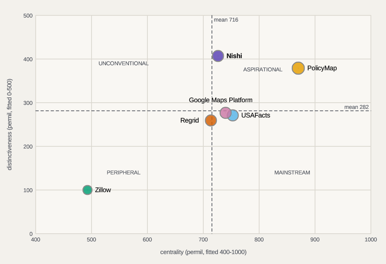
The four-quadrant map the field uses for brand strategy (Dawar and Bagga, HBR June 2015), re-derived from this matrix on every publish. Centrality is the share of the category's feature mass a player covers, each feature weighted by how many hold it; distinctiveness is the average lead over each rival on the rows the player holds; breadth is the depth-weighted share of the whole matrix (the bubble); depth is how deeply the rows held are held; momentum is the day-over-day move off the spine (green rising, red falling, grey until day two); the dashed path runs first day → previous day → today. Dividers are the category means. Axes are fitted to the field of play, so read the tick numerals, not the frame. Rival marks are documented presence, so a rival's position reads the record, never its quality. The picture grades its own readability below; the table beside it is the same data for a screen reader or a second method.
knowledge/compare/civicmap.cdmap (cut|x|y, cube|x|y|z); absent = the HBR defaultsbubble area = breadth · ring = momentum (green rising, red falling, grey until day two) · dashed = category means · axes fitted to the field of play: centrality 400–1000, distinctiveness 0–500 of 0–1000 permil (the full range put every player in one corner)
readability of the 2D cut, self-graded by the layout ruler: label overlaps 0 · labels over marks 0 · off-canvas 0 · unresolved labels 0 · mark overlaps 1 (a fact of the data: two players that close are that close) · data spread 620 permil of the plot · quadrant words unseated 0
text contrast, measured with wcag2-ratio (floors from contrast.conf), light theme: labels 16.24 (floor 4.50) · notes 16.24 (floor 4.50) · quadrant words 5.89 (floor 4.50) · tick numerals 5.89 (floor 4.50) · axis titles 5.59 (floor 4.50) · dark theme: labels 13.78 (floor 4.50) · quadrant words 5.55 (floor 4.50) · axis titles 5.97 (floor 4.50) · dark classes under their floor 0 (one figure serves both themes: a dark shortfall is a token to fix, never a class to hide) · classes refused under their floor 0 (a refused class is not drawn; the scale classes are measured, never hidden) · export: SVG PNG (receipt, rendered by the estate's own rasteriser from this page)

readability of the 3D cube, self-graded by the layout ruler: label overlaps 0 · labels over marks 0 · off-canvas 0 · unresolved labels 0 · mark overlaps 10 (a fact of the data: two players that close are that close) · data spread 95 permil of the plot
10 panels over 5 registered axes, every pair once (the lower axis on x, the higher on y) · each panel fitted to its own field of play, first and last tick numerals shown · no labels in a small cut, the legend names the colours; the grade below reports the mark terms only (MM summed over the panels, spread averaged)
readability of the small multiples, self-graded by the layout ruler: label overlaps 0 · labels over marks 0 · off-canvas 0 · unresolved labels 0 · mark overlaps 23 (a fact of the data: two players that close are that close) · data spread 513 permil of the plot
| Player | Quadrant | centrality | distinctiveness | breadth | depth | momentum | Rows held | Days on spine | First seen |
|---|---|---|---|---|---|---|---|---|---|
| Nishi | Aspirational | 727 | 408 | 419 | 755 | 0 since 2026-09-23 | 15 | 10 | 2026-09-15 |
| PolicyMap | Aspirational | 870 | 380 | 469 | 745 | 0 since 2026-09-23 | 17 | 10 | 2026-09-15 |
| USAFacts | Mainstream | 753 | 271 | 345 | 666 | 0 since 2026-09-23 | 14 | 10 | 2026-09-15 |
| Zillow | Peripheral | 493 | 100 | 160 | 541 | 0 since 2026-09-23 | 8 | 10 | 2026-09-15 |
| Regrid | Peripheral | 714 | 260 | 308 | 757 | 0 since 2026-09-23 | 11 | 10 | 2026-09-15 |
| Google Maps Platform | Mainstream | 740 | 277 | 333 | 750 | 0 since 2026-09-23 | 12 | 10 | 2026-09-15 |
| Day | Matrix rows reviewed | Players recorded |
|---|---|---|
| 2026-09-15 | 27 | 6 |
| 2026-09-16 | 27 | 6 |
| 2026-09-17 | 27 | 6 |
| 2026-09-18 | 27 | 6 |
| 2026-09-19 | 27 | 6 |
| 2026-09-20 | 27 | 6 |
| 2026-09-21 | 27 | 6 |
| 2026-09-22 | 27 | 6 |
| 2026-09-23 | 27 | 6 |
| 2026-10-08 | 27 | 6 |
players 6|matrix rows 27|feature mass 77|centrality mean 716|distinctiveness mean 282|axes 5|spine days 10 (shown 10)|rows written today 0|readability defects 2D 0 cube 0|spine knowledge/status/cdmap/civicmap.spine
Capability matrix — measured against source
◉ authored stronger claim; source present● present◐ partial○ absent? unassessed; excluded from relative comparison · click any capability for its evidence
Peer cell coverage: authored assessed 135, unassessed 0. Authored assessments are not verified outcomes.
No capabilities match this filter or search.
| Capability | Nishi | PolicyMap | USAFacts | Zillow | Regrid | Google Maps Platform |
|---|---|---|---|---|---|---|
| MAP | ||||||
Real-OSM sovereign vector render, zero third-party map librariesMeasured:r_code exists in runtime/_hdl_build/nx_geo_osmrender.nx, verified at emit. LIVE: real OpenStreetMap ways under ODbL [odbl] classified, projected and drawn layered -- water, parks, footways, roads -- with no Leaflet, Mapbox or Google anywhere in the chain; the US extract source refreshes daily [geofabrik]. The incumbents all render on someone else's map stack Adoption: BUILT-UNPROMOTED — PARTIAL: compiled, never promoted to the serving root: /api/promote it.Pros Implementing source symbol found; runtime acceptance separate; ahead of PolicyMap, Zillow, RegridCons behind Google Maps Platform (leads); not adopted yet: compiled, never promoted to the serving root: /api/promote it | ● | ◐ | ● | ◐ | ◐ | ◉ |
Web-mercator slippy tile addressingMeasured:geo_webmerc_tile exists in runtime/_hdl_build/nx_geo_webmerc.nx, verified at emit. LIVE lib, gated: the web's z-x-y tile scheme integer-exact -- the addressing half of serving our own tiles instead of buying map loads by the thousand [gmp] Adoption: LIB-GATE-ONLY importers=1 — PARTIAL: imported only by validation organs (gates, tests, benches): wire it into a shipping program.Pros Implementing source symbol found; runtime acceptance separateCons behind Google Maps Platform (leads); not adopted yet: imported only by validation organs (gates, tests, benches): wire it into a shipping program | ● | ● | ● | ● | ● | ◉ |
County choropleth raster fillMeasured:geo_raster_fill exists in runtime/_hdl_build/nx_geo_raster.nx, verified at emit. LIVE lib, gated: integer scanline polygon fill, even-odd rule. The choropleth is PolicyMap's core product [policymap]; ours is a primitive we own end to end Adoption: LIB-GATE-ONLY importers=2 — PARTIAL: imported only by validation organs (gates, tests, benches): wire it into a shipping program.Pros Implementing source symbol found; runtime acceptance separate; ahead of ZillowCons behind PolicyMap (leads); not adopted yet: imported only by validation organs (gates, tests, benches): wire it into a shipping program | ● | ◉ | ● | ○ | ● | ● |
Point-to-county spatial joinMeasured:geo_spatial_join exists in runtime/_hdl_build/nx_geo_join.nx, verified at emit. LIVE lib, gated: the ST_Contains staple, integer-exact ray-cast over a pooled vertex buffer -- the primitive that turns any lat-lon record into a county row. Parcel-joined records are Regrid's whole business [regrid] Adoption: LIB-WIRED importers=2 nonval=1 — fully adopted (top of its ladder).Pros Implementing source symbol found; runtime acceptance separate; fully adopted on the estate ladderCons behind Regrid (leads) | ● | ● | ● | ● | ◉ | ● |
Deterministic integer routing and isochronesMeasured:geo_isochrone exists in runtime/_hdl_build/nx_geo_route.nx, verified at emit. LIVE lib, gated: integer-meter Dijkstra with exact deterministic tie-breaking plus isochrone extraction; Google routes best-in-field [gmp] on float weights that admit non-deterministic ties Adoption: LIB-WIRED importers=2 nonval=1 — fully adopted (top of its ladder).Pros Implementing source symbol found; runtime acceptance separate; ahead of PolicyMap, USAFacts, Zillow, Regrid; fully adopted on the estate ladderCons behind Google Maps Platform (leads) | ● | ○ | ○ | ○ | ○ | ◉ |
Sovereign geocoding, forward and reverseMeasured:geocode_forward exists in runtime/_hdl_build/nx_geo_geocode.nx, verified at emit. LIVE lib, gated: gazetteer place-to-coordinate in both directions, with fuzzy typo-tolerant lookup riding beside it in the places lib rival marks uncited — the Yes, Best or Part codes on this row are an observation read with no reference mark behind them Adoption: LIB-GATE-ONLY importers=1 — PARTIAL: imported only by validation organs (gates, tests, benches): wire it into a shipping program.Pros Implementing source symbol found; runtime acceptance separate; ahead of USAFactsCons behind Google Maps Platform (leads); not adopted yet: imported only by validation organs (gates, tests, benches): wire it into a shipping program | ● | ● | ○ | ● | ● | ◉ |
Hex-grid spatial indexing, H3-classMeasured:geo_hex_disk_size exists in runtime/_hdl_build/nx_geo_h3.nx, verified at emit. LIVE lib, gated: hexagonal index in cube coordinates with uniform-distance neighbors, integer-exact -- the aggregation grid for point layers like crashes and 311 at map scale rival marks uncited — the Yes, Best or Part codes on this row are an observation read with no reference mark behind them Adoption: LIB-GATE-ONLY importers=1 — PARTIAL: imported only by validation organs (gates, tests, benches): wire it into a shipping program.Pros Implementing source symbol found; runtime acceptance separate; ahead of PolicyMap, USAFacts, ZillowCons not adopted yet: imported only by validation organs (gates, tests, benches): wire it into a shipping program | ● | ○ | ○ | ○ | ● | ● |
Measured-exceed geo capability censusMeasured:gc_measure exists in runtime/_hdl_build/nx_geo_census.nx, verified at emit. LIVE: a geo feature counts as PRESENT only when a real Nishi gate log is GREEN, never asserted; reach permil ratchets as rungs land -- the scoreboard the map rows above answer to Adoption: BUILT-UNPROMOTED — PARTIAL: compiled, never promoted to the serving root: /api/promote it.Pros Implementing source symbol found; runtime acceptance separate; ahead of PolicyMap, USAFacts, Zillow, Regrid, Google Maps PlatformCons not adopted yet: compiled, never promoted to the serving root: /api/promote it | ● | ○ | ○ | ○ | ○ | ○ |
| JUDGE | ||||||
Real-value vs nominal-price manipulation gateSource present; authored stronger claim:fr_ev_present in runtime/_hdl_build/nx_flip_real.nx, verified at emit. LIVE and repointed from realestate where it is graded: bottom-up net-tangible backing against asking price with manipulation claimed only on named evidence classes -- the instrument the listings field does not ship while its practices draw federal suits [ftczillow]. Realestate owns the ruler; this board renders its verdicts on the map Adoption: REGISTERED-DARK — PARTIAL: callable, authorised, completed MCP invocation not established by supplied journal window; lifetime history unknown (direct execution may be recorded elsewhere; this scan does not establish lifetime use); no execution surface runs it either (clock, cron, daemon, roster, actlog and surfaced forks checked).Pros Source symbol found; stronger capability claim is authored; ahead of PolicyMap, USAFacts, Zillow, Regrid, Google Maps PlatformCons not adopted yet: callable, authorised, completed MCP invocation not established by supplied journal window; lifetime history unknown (direct execution may be recorded elsewhere; this scan does not establish lifetime use); no execution surface runs it either (clock, cron, daemon, roster, actlog and surfaced forks checked) | ◉ | ○ | ○ | ○ | ○ | ○ |
| DATA | ||||||
Layer admission -- source, licence, resolution, cadence as rowsMeasured:cm_layer_admit exists in runtime/nx_civicmap_lib.nx, verified at emit. PolicyMap's admitted-layer catalog is the practice bar [policymap]. Contract = a layer is DATA rows refused without a licence and a mirror; a bad layer gets better data, never removal Adoption: LIB-WIRED importers=2 nonval=1 — fully adopted (top of its ladder).Pros Implementing source symbol found; runtime acceptance separate; ahead of Zillow; fully adopted on the estate ladderCons behind PolicyMap (leads) | ● | ◉ | ● | ○ | ● | ● |
Point-to-county FIPS join over the admitted baseMeasured:cm_fips_join exists in runtime/nx_civicmap_lib.nx, verified at emit. LANDED 2026-08-27, gate-proven: composes the integer-exact geo_spatial_join and DISCRIMINATES between counties rather than merely answering; a point in no loaded county is reported OUTSIDE COVERAGE, never as a zero. Parcel-joined records are Regrid's whole business [regrid] Adoption: LIB-WIRED importers=2 nonval=1 — fully adopted (top of its ladder).Pros Implementing source symbol found; runtime acceptance separate; fully adopted on the estate ladderCons behind Regrid (leads) | ● | ● | ● | ● | ◉ | ● |
US county base BANKED -- public-domain TIGER polygonsDARK —runtime/nx_civicmap.nx EXISTS but does not declare cm_tiger_bank: something shipped at this path under another name, and this mark would read open forever. Repoint the contract to the real entry point (the plan rung AND this row) or rename the function; the flip follows on the next beat, and the comparewatch- plane row reads DARK until then. SPLIT OUT OF THE JOIN ROW ON PURPOSE 2026-08-27: the join mechanism above is proven, the national county bank is NOT, and one row claiming both would have read as national coverage the day the mechanism landed. Census TIGER county polygons are public domain [tiger]. **THE DATA HALF IS DONE 2026-08-28**: the national set cb_2023_us_county_20m is BANKED AND PINNED in the estate evidence store, 900,375 bytes from the authoritative Census host [tigerdata]. What remains is the INGEST -- a ZIP plus shapefile reader that yields county rows -- and the partition summing to the county count and printingPros none measured yetCons behind PolicyMap, USAFacts, Zillow, Regrid (leads), Google Maps Platform; open contract; expected source declaration not established | ○ | ● | ● | ● | ◉ | ● |
| MAP | ||||||
Native county choropleth with an ABSTENTION contractSource present; authored stronger claim:cm_choropleth_emit in runtime/nx_civicmap_lib.nx, verified at emit. LANDED 2026-08-27, gate-proven, and the EXCEED on this board: an unobservable county emits a NAMED reason and NO value attribute at all, so a suppressed cell is structurally incapable of being read as a quantity. County statistics are routinely suppressed at small counts and ignoring that censoring understates rural rates [wondersup]; every rival paints what it has. Own projection, own SVG, produced-work licence [osmproduced] with the OSM credit printed [osmattrib], zero third-party JS. The raster primitive is composed by the GATE as an independent coverage oracle, not by the emitter Adoption: LIB-WIRED importers=2 nonval=1 — fully adopted (top of its ladder).Pros Source symbol found; stronger capability claim is authored; ahead of USAFacts, Zillow, Regrid, Google Maps Platform; fully adopted on the estate ladderCons none on the measured axes (rival marks are documented presence, not depth) | ◉ | ◉ | ● | ○ | ● | ● |
| LAYER | ||||||
Potholes and 311 service requestsDARK —runtime/nx_civicmap.nx EXISTS but does not declare cm_open311: something shipped at this path under another name, and this mark would read open forever. Repoint the contract to the real entry point (the plan rung AND this row) or rename the function; the flip follows on the next beat, and the comparewatch- plane row reads DARK until then. The Open311 standard is alive per-city -- the mirrored SF endpoint lists pothole service today [open311]; the big bulk feeds are point-resolution and daily [sf311] and NYC's flagship silently re-scoped to 2020-plus at the old identifier [nyc311]. Contract = per-city coverage printed; a city sample never publishes as a national factPros none measured yetCons behind PolicyMap; open contract; expected source declaration not established | ○ | ● | ○ | ○ | ○ | ○ |
Power outage historyDARK —runtime/nx_civicmap.nx EXISTS but does not declare cm_outage: something shipped at this path under another name, and this mark would read open forever. Repoint the contract to the real entry point (the plan rung AND this row) or rename the function; the flip follows on the next beat, and the comparewatch- plane row reads DARK until then. EAGLE-I is the national public outage history at county resolution in 15-minute intervals, Globus-delivered, with no licence stated on its landing pages [eaglei]; ODIN is the near-real-time county complement [odin] and the OE-417 disturbance events republish monthly [oe417]. Contract = county outage-hours with the coverage bound printed beside every figure and the licence question resolved at admission, not assumedPros none measured yetCons open contract; expected source declaration not established | ○ | ○ | ○ | ○ | ○ | ○ |
Traffic crashesDARK —runtime/nx_civicmap.nx EXISTS but does not declare cm_crash: something shipped at this path under another name, and this mark would read open forever. Repoint the contract to the real entry point (the plan rung AND this row) or rename the function; the flip follows on the next beat, and the comparewatch- plane row reads DARK until then. FARS ships every fatal crash since 1975 as no-auth bulk files with coordinate-bearing accident records [fars]. Contract = point rollup to county through the join, freshness stamped per layerPros none measured yetCons behind PolicyMap, USAFacts; open contract; expected source declaration not established | ○ | ● | ● | ○ | ○ | ○ |
Road roughness and bridge conditionDARK —runtime/nx_civicmap.nx EXISTS but does not declare cm_roads: something shipped at this path under another name, and this mark would read open forever. Repoint the contract to the real entry point (the plan rung AND this row) or rename the function; the flip follows on the next beat, and the comparewatch- plane row reads DARK until then. The National Bridge Inventory publishes every highway bridge's condition annually [nbi] and HPMS 2024 carries segment condition under a licence that reads available for unrestricted public use [hpms]. Contract = two admitted layers, never one blended number [roads_iri1986] [roads_dim2014] [roads_pci2024] [roads_dqm2019] [roads_lcca] [roads_paver]Pros none measured yetCons behind PolicyMap, USAFacts, Google Maps Platform; open contract; expected source declaration not established | ○ | ● | ● | ○ | ○ | ◐ |
Cancer counts with suppression honestyDARK —runtime/nx_civicmap.nx EXISTS but does not declare cm_cancer: something shipped at this path under another name, and this mark would read open forever. Repoint the contract to the real entry point (the plan rung AND this row) or rename the function; the flip follows on the next beat, and the comparewatch- plane row reads DARK until then. County rates live at State Cancer Profiles with sub-16 suppression and no official bulk access [scpscrape], and the literature shows ignoring suppression systematically understates rural mortality [wondersup]. Contract = a suppressed cell renders UNOBSERVABLE, never zero; registry coverage printed -- abstention the index field does not practicePros none measured yetCons behind PolicyMap (leads), USAFacts; open contract; expected source declaration not established | ○ | ◉ | ● | ○ | ○ | ○ |
Downwind overlay -- fallout dose beside cancerDARK —runtime/nx_civicmap.nx EXISTS but does not declare cm_fallout: something shipped at this path under another name, and this mark would read open forever. Repoint the contract to the real entry point (the plan rung AND this row) or rename the function; the flip follows on the next beat, and the comparewatch- plane row reads DARK until then. NCI's county thyroid-dose record survives only behind an interactive calculator with no machine-readable file [nci131]; modern reconstruction shows deposition across all 48 contiguous states beyond compensation boundaries [fallout]; RECA is live again with claims through the end of 2027 [reca]. Contract = dose geography rendered beside the cancer layer with correlation-is-not-causation printed and the epidemiology citedPros none measured yetCons open contract; expected source declaration not established | ○ | ○ | ○ | ○ | ○ | ○ |
Taxes, transport cost, jobs and agricultureDARK —runtime/nx_civicmap.nx EXISTS but does not declare cm_tax_jobs: something shipped at this path under another name, and this mark would read open forever. Repoint the contract to the real entry point (the plan rung AND this row) or rename the function; the flip follows on the next beat, and the comparewatch- plane row reads DARK until then. Government-unit tax collections [cog], ACS property-tax and commute measures [acsapi], BEA county income and GDP [bea] and county agriculture [nass] -- each its own data admission. The transport-cost incumbent models the whole country [hnt] but its licence forbids redistribution [hntlic], so our transport layer derives from the public sources insteadPros none measured yetCons behind PolicyMap (leads), USAFacts (leads); open contract; expected source declaration not established | ○ | ◉ | ◉ | ○ | ○ | ○ |
Drinking water and air qualityDARK —runtime/nx_civicmap.nx EXISTS but does not declare cm_env: something shipped at this path under another name, and this mark would read open forever. Repoint the contract to the real entry point (the plan rung AND this row) or rename the function; the flip follows on the next beat, and the comparewatch- plane row reads DARK until then. Drinking-water violations join by county and service area, quarterly [sdwa]; validated air data carries a stated half-year lag [aqs]. Contract = the lag and the join geography print on the pagePros none measured yetCons behind PolicyMap (leads), USAFacts; open contract; expected source declaration not established | ○ | ◉ | ● | ○ | ○ | ○ |
| INDEX | ||||||
Decomposable QoL score with abstentionSource present; authored stronger claim:cm_qol_index in runtime/nx_civicmap_lib.nx, verified at emit. LANDED 2026-08-28, gate-proven, and an EXCEED: a missing axis is DROPPED from the denominator, never imputed and never scored zero, and the score cannot be separated from its observed-of-declared count. The proving tooth is arithmetic -- a county observed on ONE of three axes at that axis's best must score 1000, where imputing zeros yields 333, and the two implementations differ nowhere else. Direction is declared per axis and bite-proven. County Health Rankings publishes composite county ranks under a no-commercial-use licence [chr] and PLACES models health measures under ODbL [places] -- both graded, neither republished. Contract = a county score is a sum of NAMED signal rows and always decomposes; a missing axis abstains and the denominator prints beside the score Adoption: LIB-WIRED importers=2 nonval=1 — fully adopted (top of its ladder).Pros Source symbol found; stronger capability claim is authored; ahead of PolicyMap, USAFacts, Zillow, Regrid, Google Maps Platform; fully adopted on the estate ladderCons none on the measured axes (rival marks are documented presence, not depth) | ◉ | ◐ | ◐ | ○ | ○ | ○ |
| ENGINE | ||||||
Partnership opportunity ranker -- need x funding x capabilityDARK —runtime/nx_civicmap.nx EXISTS but does not declare cm_need_rank: something shipped at this path under another name, and this mark would read open forever. Repoint the contract to the real entry point (the plan rung AND this row) or rename the function; the flip follows on the next beat, and the comparewatch- plane row reads DARK until then. Federal contract opportunities require only an API key [samgov], the grant search needs no auth at all [grantsgov], and county-level federal spend is open [usaspending]. Contract = measured need joined to live funding and live capability; every rank prints its grounds; composes the civic-axes spend contract, never a second spend rulerPros none measured yetCons open contract; expected source declaration not established | ○ | ○ | ○ | ○ | ○ | ○ |
| LAYER | ||||||
Parcels on the mapDARK —runtime/nx_civicmap.nx EXISTS but does not declare cm_parcel_layer: something shipped at this path under another name, and this mark would read open forever. Repoint the contract to the real entry point (the plan rung AND this row) or rename the function; the flip follows on the next beat, and the comparewatch- plane row reads DARK until then. Regrid is the commercial parcel incumbent [regrid]; free statewide programs exist and Montana's cadastral is existence-witnessed [mtcad]; the public-domain address spine joins listings to parcels [nad]; flood zones overlay from the open federal layer [nfhl]; building footprints ride Overture's theme-split licences [overture]. Contract = renders realestate's parcel intake with per-county coverage printedPros none measured yetCons behind PolicyMap, Zillow, Regrid (leads); open contract; expected source declaration not established | ○ | ● | ○ | ◐ | ◉ | ○ |
| INTAKE | ||||||
FSBO owner-direct listingsDARK —runtime/nx_civicmap.nx EXISTS but does not declare cm_fsbo_intake: something shipped at this path under another name, and this mark would read open forever. Repoint the contract to the real entry point (the plan rung AND this row) or rename the function; the flip follows on the next beat, and the comparewatch- plane row reads DARK until then. FSBO fell to five percent of sales and most FSBO sellers barely market [narfsbo] -- a trust wedge, not a volume source. Contract = owner-submitted only, never scraped; acreage and price pre-filled and checked against the address and parcel record [nad]; feeds the map and the realestate judgesPros none measured yetCons behind Zillow; open contract; expected source declaration not established | ○ | ○ | ○ | ◐ | ○ | ○ |
| TRUTH | ||||||
Dollars-per-acre against recorded salesSource present; authored stronger claim:cm_acre_truth in runtime/nx_civicmap_lib.nx, verified at emit. LANDED 2026-08-28, gate-proven, and an EXCEED nobody in the field ships: it NEVER alleges fraud (only that an asking price sits outside the RECORDED band, a fact about the record), it returns UNPROVABLE-NON-DISCLOSURE in the eleven states where prices are not public [ndstates] -- proven by a tooth where comparables ARE present and the ruler refuses anyway, so the law wins over the available arithmetic -- and UNPROVABLE-THIN below a declared minimum, kept a SEPARATE verdict because one refusal is fixable by more data and the other never is. Median not mean, proven numerically: two absurd sales leave the median inside the recorded range while dragging the mean twentyfold outside it, so the band cannot be walked up by posting extremes. Eleven non-disclosure states never publish sale prices [ndstates] and the repeat-sales index is the manipulation-resistant trend backbone where they do [fhfa]. No enforcement record documents per-acre gaming as such -- this layer GENERATES that evidence from parcel-vs-listing deltas. Contract = the recorded-transfer distribution per county; an out-of-distribution listing claim is flagged with named evidence through the manipulation gate; non-disclosure states print UNPROVABLE, never a guess Adoption: LIB-WIRED importers=2 nonval=1 — fully adopted (top of its ladder).Pros Source symbol found; stronger capability claim is authored; ahead of PolicyMap, USAFacts, Zillow, Regrid, Google Maps Platform; fully adopted on the estate ladderCons none on the measured axes (rival marks are documented presence, not depth) | ◉ | ○ | ○ | ○ | ○ | ○ |
| EVIDENCE | ||||||
Sovereign mirrored and pinned reference register for this fieldMeasured:knowledge/fetched/cmp_civicmap exists in knowledge/compare/civicmap.refs, verified at emit. Every rival claim on this page resolves to a mirror in the estate evidence store, content-pinned by hash and re-measured on every emit Adoption: ABSENT — PARTIAL: no source and no binary: this is a build contract, not a partial deploy.Pros Implementing source symbol found; runtime acceptance separate; ahead of PolicyMap, USAFacts, Zillow, Regrid, Google Maps PlatformCons not adopted yet: no source and no binary: this is a build contract, not a partial deploy | ● | ○ | ○ | ○ | ○ | ○ |
| Class | Count | Note |
|---|---|---|
| rows with rival marks | 20 | rows carrying a Yes, Best or Part in a rival column |
| cited | 18 | a reference mark resolves to a pinned mirror |
| uncited | 2 | an observation read, badged until a reference lands |
| rows, summed | 20 | RECONCILED: the parts sum to the total 20 |
Delivery and evidence
Inspect risks, technical debt, rendered observations, experiments and references. Read scope and limitations alongside every result.
Risk register
| Risk | Likelihood x impact | Mitigation |
|---|---|---|
| ODbL share-alike could contaminate our civic layers if the combined store reads as a derivative database | probable x high | layer stores stay SEPARATE feature types per the board-endorsed guideline [osmlayers]; the join happens at RENDER as an attributed produced work; any database redistribution gets its own licence-review row first |
| Small-count suppression read as zero paints false safety on the cancer layer | probable x high | CM8 abstention is a gate tooth: a suppressed cell that renders as a number is a RED |
| A city-sample 311 layer published as a national fact | probable x medium | per-layer coverage rows on the published page; the no-sampling law applies to the render, not just the analysis |
| The gaming arrives at our own door as fake FSBO submissions | possible x high | owner attestation plus parcel-record pre-fill plus recorded-sale cross-check through the manipulation gate; the refusal record is public |
| Several federal hosts 403 the estate fetcher, so a claim can silently rest on a search snippet | probable x medium | refs carry provenance; a claim whose page could not be mirrored stays out of the notes or is re-routed to a fetchable authority, as the cancer and agriculture rows already were |
| A watch contract flips on symbol existence, so a stub reads green | possible x high | the flip is the receipt; each rung's gate is the proof |
Release history and work log
| When | Rung | Kind | Entry |
|---|---|---|---|
| 2026-09-10 | CM7 | defer | 2026-09-10 OPERATOR REQUEST RETAINED: road and paved-surface investment intelligence, deferred behind Beach and swarm. Reuse Civic Map CM7 condition, CM5 pothole intake, CM12 funding/procurement and existing geo/librarian/Compare owners. Eventual scope includes public and private roads, streets, parking lots, driveways, sidewalks, paved paths, yards and airfields; no claim of uniform coverage or one rating standard. First pilot is one authorized city/county sample with calibrated ground truth; no product implementation, field survey, build, price, ETA or served UI claimed. |
| 2026-09-10 | CM7 | research | 2026-09-10 LINEAGE AND FIELD: late-1970s PAVER management; 1986 IRI calibration; LTPP distress manual lineage 1987 to 2014; ASTM D6433-24 PCI; FHWA lifecycle agency plus work-zone user costs; RDD2022 damage detection; UAV real/synthetic studies; August 2026 local-domain transfer. Current vendor bars: PAVER, Trimble Unity Maintain Pavement, vialytics. Michelin Better Roads is HISTORICAL: official notice stops new projects and discontinues by end-2025. Primary-source refs roads_* appended with mirror and pin unknown, no SOTA ranking or vendor ROI accepted. |
| 2026-09-10 | CM7 | measure | DEFERRED ACCEPTANCE CONTRACT: bind segment/area geometry, ownership, surface, sensor, calibration, ground sampling distance, trajectory, weather, time and raw artifact identity. Compare blinded engineer distress/severity ratings plus calibrated profile/depth/fault measurements on identical locations; report disagreement, bias, absolute error, repeatability across days/operators/devices and uncertainty by surface and lighting. Keep PCI, IRI, rut/fault depth, friction and structural capacity separate; RGB/drone imagery alone cannot establish all. Train/test cities and survey passes must remain separate; include negative controls and abstention. Track cost per surveyed lane-km or paved area, coverage, field/compute/review time, first-byte-to-usable-evidence and API/MCP operation receipts with unknowns explicit. |
| 2026-09-10 | CM7 | plan | DEFERRED INVESTMENT AND TRUST: compare preservation/rehabilitation/reconstruction/defer options using agency cost, closure hours, user delay, construction calendar and uncertainty, treatment history, weather/traffic, lifecycle cost and budget scenarios; backtest degradation and treatment effects rather than equating one image with remaining life. Preserve foundational research, replication attempts, contradictions, corrections/retractions status and open questions. UAV study reports public-domain F1 loss despite target-domain benefit; new 2026 study has fixed-split/interval limitations, no estate replication. Privacy: authorized capture, minimize/redact faces/plates, private parcels access-controlled, raw evidence retained under governed policy. Procurement anomalies tie quantities, bids, change orders, invoices and actual progress to provenance and human review; flags are not proof of corruption. Research receipt t67-road-investment-research.json; no automatic queue/resumption or public delivery claimed. |
Person · product · place — not yet measured for this domain
knowledge/compare/civicmap.ppp (rows surface|nishi or c1..c4|label|url|connect naming OUR live surface and each rival's front door), run nx_ppp_probe domain civicmap, and this section fills itself on the next beat: the same ruler on both sides — privacy and CX (third-party hosts, tracker classes, cookies, security headers), design and longevity (design hygiene, computed WCAG contrast, render-blocking resources, unsized media, script weight, theme and motion queries), findability (landmarks, skip link, on-site search, breadcrumb, headings, internal links).The field — discovered, not chosen
Rows written by nx_field_discover from civicmap.seeds: the industry's own lists (Wikipedia wikitext, GitHub topics, awesome lists) read mechanically, every candidate counted across seeds. The matrix columns above are a SEAT'S pick; this band is the population they were picked from, and the stats line measures one against the other. A rival here is a lead, never a verdict — it earns a column when its capabilities are read and pinned.
| Class | Count | Note |
|---|---|---|
| seeds | 5 | |
| scanned | 5 | |
| fetched | 5 | |
| reused | 0 | |
| failed | 0 | |
| named | 5 | |
| candidates | 5 | |
| mentions | 5 | |
| capped | 0 |
| Rank | Rival | Seeds | Mentions | First seed | Kind | Link |
|---|---|---|---|---|---|---|
| 1 | PolicyMap | 1 | 1 | col0-policymap | named | https://www.policymap.com/ |
| 2 | USAFacts | 1 | 1 | col1-usafacts | named | https://usafacts.org/how-to-cite-usafacts/ |
| 3 | Zillow | 1 | 1 | col2-zillow | named | https://techcrunch.com/2026/08/24/zillow-and-redfin-settle-ftc-antitrust-case/ |
| 4 | Regrid | 1 | 1 | col3-regrid | named | https://regrid.com/api |
| 5 | Google Maps Platform | 1 | 1 | col4-google | named | https://developers.google.com/maps/billing-and-pricing/pricing |
field candidates 5|shown 5 of 5|matrix columns in the field 5 of 5|discovered rivals with no column 0|malformed rows 0 (counted, never rendered)|read-capped 0
Exclusive and shared capabilities
This board grades 27 capabilities: 26 exclusive to it and 1 shared with other boards. Shared rows on this page: 1 = home here 0 + home elsewhere 0 + ambiguous 1 + undecided 0 + refused 0 (partition 1); undecided = unmapped 0 + unproven 0 + unevidenced 0; homonyms 0; since the previous census: new 0, resolved 0. Census FRESH age_s=7012.
| Capability | Organ | Boards grading it | Home | Rule | Evidence | Standing on this board |
|---|---|---|---|---|---|---|
| fr_ev_present | nx_flip_real.nx | alignbiz, carflip+, realestate+, civicmap | — | ambiguous | gates | ambiguous |
Gaps from the record — what the estate does that no board carries
The record census (nx_goalmap record) reads the invoked-tool population and every plan queue row and files each organ or directive that NO matrix, plan or gates row names. A row here is a callout the boards missed: adjudicate it onto a board or declare it infrastructure. Census state STALE (age 1396117 s), sources read 4 of 7 declared — a BLIND census is a FLOOR: unread sources can only add rows.
| kind | name | board | source | evidence |
|---|
rows shown 0|this board's directives 0|estate-wide un-boarded organs 452 (listed in full on /compare/ecosystem)|census rows 639|malformed 0 (counted, never rendered)
References
- [odbl] Open Data Commons. Open Database License ODbL 1.0 full text -- share-alike attaches to derivative databases; section 4.5b says a produced work does not create a derivative database; section 4.3 notice requirement. publisher · read in our library
knowledge/fetched/cmp_civicmap_odbl.html· pinh058a4f42571027bab20c80fcbfa0530efe7ccc142a4bbd081bfdabf55e0e2beb· accessed 2026-08-27 · published-standardGrounds: The OSM render row and the ODbL risk row: the licence the base geometry rides. - [osmlayers] OSM Foundation. Horizontal Map Layers community guideline, board-endorsed 2014 -- witnessed verbatim in the mirror: if all data for a Feature Type is from non-OpenStreetMap sources the ODbL share-alike conditions do not apply to that Feature Type. publisher · read in our library
knowledge/fetched/cmp_civicmap_osmlayers.html· pinh689e4d553fdbe0a9896c58aeb3ddef80f6be2d9ce5647561ec708ec566529d5b· accessed 2026-08-27 · published-standardGrounds: The layer-admission row and the ODbL risk row: the mechanism that keeps our civic layers proprietary over an OSM base. - [osmproduced] OSM Foundation. Produced Work community guideline -- the extraction test; rasters are usually produced works and a produced work may carry its own licence. publisher · read in our library
knowledge/fetched/cmp_civicmap_osmproduced.html· pinh19a151dcf73ae9fcdafacc91108a0a8b699244dfe19a751b2edb1d92133f0af6· accessed 2026-08-27 · published-standardGrounds: The choropleth emit row: rendered maps may carry our licence with the required notice. - [osmattrib] OSM Foundation. Attribution Guidelines, board-adopted 2021 -- corner credit to OpenStreetMap with a link to the copyright page; multi-source qualification permitted. publisher · read in our library
knowledge/fetched/cmp_civicmap_osmattrib.html· pinh129854d6f56ddb4b77800c25d5d638f24452cab3200431899b6ff3559bc9d9f4· accessed 2026-08-27 · published-standardGrounds: The choropleth emit row: what the published page must print. - [geofabrik] Geofabrik. United States OSM extract page -- us-latest.osm.pbf regenerated daily under ODbL 1.0 with per-state sub-extracts; the working fork source for US geometry. publisher · read in our library
knowledge/fetched/cmp_civicmap_geofabrik.html· pinheceb997feb2a27daca8baa2faa1214be4bff7c3872fd1b069a4a09993a686147· accessed 2026-08-27 · mirrored-indexGrounds: The OSM render row: where the base geometry comes from and how fresh it is. - [overture] Overture Maps Foundation. Attribution and licensing page -- transportation, base, buildings and divisions themes are ODbL; places is CDLA-Permissive-2.0; addresses ride per-jurisdiction permissive government licences. publisher · read in our library
knowledge/fetched/cmp_civicmap_overture.html· pinhadd8120c71e70efc1d13b93556ba9872c1b377ad5a09e1c31d3dd668c09038ac· accessed 2026-08-27 · vendor-docGrounds: The parcel and address rows: the theme-split licensing of the joint-industry base data. - [tiger] US Census Bureau via data.gov. TIGER/Line shapefile catalog record, current nation, state and equivalent entities -- Creative Commons CC0 public-domain dedication, annual vintages. publisher · read in our library
knowledge/fetched/cmp_civicmap_tiger.html· pinh6a4a9280bad458291fa72558cec7ff7a63107c6f751e559d190db1db1010fdcf· accessed 2026-08-27 · datasetGrounds: The county-base row: the public-domain county polygons every layer joins onto. - [nad] US DOT via data.gov. National Address Database file geodatabase -- public domain, partner-contributed address points with a June 2026 compile; coverage varies by state participation. publisher · read in our library
knowledge/fetched/cmp_civicmap_nad.html· pinh60b7419894b2359d760c305f3b0a8eee46fcacee6318cf13428a800d99fcf6e2· accessed 2026-08-27 · datasetGrounds: The FSBO intake and parcel rows: the address spine that pre-fills and checks an owner submission. - [gmp] Google. Maps Platform pricing page, post-March-2025 model -- per-SKU monthly free caps by Essentials, Pro and Enterprise tiers replacing the old monthly credit; dynamic map loads priced per thousand. publisher · read in our library
knowledge/fetched/cmp_civicmap_gmp.html· pinh18381d35bdd4b50f30c7c1d19d56c2ae4033f7ba02fae43441480998a8a65068· accessed 2026-08-27 · vendor-docGrounds: The Google Maps Platform column and the routing and tile rows. - [policymap] PolicyMap. Vendor home page -- US socioeconomic data mapping SaaS serving governments, universities and finance, thousands of admitted datasets, pricing unpublished. publisher · read in our library
knowledge/fetched/cmp_civicmap_policymap.html· pinh2f9f91206c8324a7cc989d807a91afd64721a711f4ef3ca6cc773cbd5378846f· accessed 2026-08-27 · vendor-docGrounds: The PolicyMap column and the layer-admission and choropleth rows: the civic-data-mapping practice bar. - [usafacts] USAFacts. How-to-cite page -- free Ballmer-funded government-data rollup publishing data and visualizations under a share-alike Creative Commons licence. publisher · read in our library
knowledge/fetched/cmp_civicmap_usafacts.html· pinh4950979cba133b900b2e249ded3a2cb2c8d64cb2e513f39959b60685d9bebbce· accessed 2026-08-27 · vendor-docGrounds: The USAFacts column: the free macro rollup with no map-first county drill. - [regrid] Regrid. API page -- national parcel data with self-serve tokens, a 30-day sandbox, batch endpoints, and enterprise licensing above ten thousand records a month. publisher · read in our library
knowledge/fetched/cmp_civicmap_regrid.html· pinhed6d7b686dfb6a99fd809a0d8b79a5864f0ea68952c8dc2528412580fc1c4039· accessed 2026-08-27 · vendor-docGrounds: The Regrid column and the parcel-layer row: the commercial parcel incumbent our free-first intake is graded against. - [ndstates] HouseCanary. Non-disclosure states explainer, updated September 2025 -- eleven states where sale prices are not public record: Alaska, Idaho, Kansas, Louisiana, Mississippi, Missouri in part, Montana, New Mexico, Texas, Utah, Wyoming. publisher · read in our library
knowledge/fetched/cmp_civicmap_ndstates.html· pinh527f0af9f9982dcceab0f0e9050cb7cf57fea02d9acf22177e23f4133f87beb5· accessed 2026-08-27 · vendor-docGrounds: The dollars-per-acre truth row: where recorded-sale ground truth is structurally impossible and the ruler must abstain. - [fhfa] FHFA. House Price Index data page -- public repeat-sales indices for all states with annual county, ZIP and tract developmental series; a transaction-derived trend backbone that a single faked listing cannot move. publisher · read in our library
knowledge/fetched/cmp_civicmap_fhfa.html· pinh162e8e2cf0a9d002d42799a217787bd7b38ad516e74c4b9727d757e8ecc64e3d· accessed 2026-08-27 · datasetGrounds: The dollars-per-acre truth row: the manipulation-resistant price-trend reference. - [narfsbo] NAR Realtor Magazine. FSBOs reach all-time low, 2025 Profile of Home Buyers and Sellers -- for-sale-by-owner fell to five percent of sales and most FSBO sellers barely market at all. publisher · read in our library
knowledge/fetched/cmp_civicmap_narfsbo.html· pinhf759aa211038d431b2ecf42a341a8ca83c6bbf91bd9718d2471b110ae7da4485· accessed 2026-09-05 · mirrored-indexGrounds: The FSBO intake row: the market size and why owner-direct submission is a trust wedge, not a volume play. - [ftczillow] TechCrunch. Zillow and Redfin settle FTC antitrust case, 2026-08-24 -- the FTC and five state attorneys general sued over the hundred-million-dollar rental-listings exclusivity deal; the settlement unwinds it. publisher · read in our library
knowledge/fetched/cmp_civicmap_ftczillow.html· pinh725c089ecbdb85dc07c90512b0f9a77e23c5fa5459c4bd969a7fef213b5f8492· accessed 2026-08-27 · mirrored-indexGrounds: The Zillow column and the dollars-per-acre truth row: documented federal scrutiny of the incumbent listing-control practices. - [eaglei] ORNL via OSTI. EAGLE-I power outage data 2014-2022 record -- county-level customers-without-power at 15-minute intervals with per-state coverage tables; downloads ride Globus; no licence is stated on the landing page. publisher · read in our library
knowledge/fetched/cmp_civicmap_eaglei.html· pinh0fd6b7e15e3497986d5e9c57b8ab4c1a13c2c7897a0fda14b5eaae0c91a2a93d· accessed 2026-08-27 · datasetGrounds: The power-outage layer row and its bar: the national public outage history and its admission caveats. - [odin] ORNL OpenEnergy Hub. ODIN real-time outages by county -- the near-real-time public complement to EAGLE-I with an export console. publisher · read in our library
knowledge/fetched/cmp_civicmap_odin.html· pinh2c1316339f776fffd9cef1df6d4fd836421e16b2868c0b58f88263f53e3668b3· accessed 2026-08-27 · datasetGrounds: The power-outage layer row: the live feed beside the history. - [oe417] EIA. Electric Power Monthly table B.1 -- major disturbances and unusual occurrences republishing the OE-417 event reports with utility, area and customers affected. publisher · read in our library
knowledge/fetched/cmp_civicmap_oe417.html· pinh9f374576c623b0ae98db5e1075811a3996e543fada94617101e8b42db5c88dcd· accessed 2026-08-27 · datasetGrounds: The power-outage layer row: the event-level disturbance record and its verified access path. - [fars] NHTSA. FARS release notes file on the static download host -- yearly national files in SAS and CSV since 1975, auxiliary derived files, and coordinate-bearing accident records. publisher · read in our library
knowledge/fetched/cmp_civicmap_fars.txt· pinh2d44757c1d00a35ed74b1a3472c115210956c7907c5050ae1f0955118b62c483· accessed 2026-08-27 · datasetGrounds: The traffic-crash layer row: the fatal-crash census, its formats and its no-auth bulk host. - [nbi] FHWA. National Bridge Inventory 2025 delimited files page -- per-bridge annual condition data as state and all-states zips, published as final by mid-June. publisher · read in our library
knowledge/fetched/cmp_civicmap_nbi.html· pinh16d8bbec2889e988ebc5b6439176a6eeb1582a20717ef3136a3cd6d7bc94f417· accessed 2026-08-27 · datasetGrounds: The road-and-bridge layer row: every US highway bridge with condition ratings and coordinates. - [hpms] BTS NTAD via ArcGIS. Highway Performance Monitoring System 2024 item record -- witnessed verbatim in the mirror: this NTAD dataset is a work of the United States government and is available for unrestricted public use; per-state feature classes, compiled December 2025. publisher · read in our library
knowledge/fetched/cmp_civicmap_hpms.json· pinh302302b0caf594aa4586249c707d524e4c736f3150d87fbb159f4e7d40fac1e7· accessed 2026-08-27 · datasetGrounds: The road-and-bridge layer row: the current road-condition vintage and its public-domain licence text. - [sdwa] EPA ECHO. SDWA data download summary -- quarterly zip of drinking-water systems, violations and enforcement joined by county and service area, no coordinates by design. publisher · read in our library
knowledge/fetched/cmp_civicmap_sdwa.html· pinh6f36cf7019ed71c8915e687e435e0a82d45b0896d828fd2abd40331bff2cb339· accessed 2026-08-27 · datasetGrounds: The environment layer row: drinking-water violations as a county-joined admission. - [aqs] EPA. AQS pre-generated air data files page -- annual and daily summaries by monitor, county and CBSA from 1980, refreshed twice a year with a stated half-year validation lag. publisher · read in our library
knowledge/fetched/cmp_civicmap_aqs.html· pinh815afb5445d66d1762caecfc5a5c4072640d7d2548638bb3c90c0ad43bdb814b· accessed 2026-08-27 · datasetGrounds: The environment layer row: validated air quality with its cadence stated honestly. - [open311] City and County of San Francisco. Live Open311 GeoReport v2 services list -- witnessed in the mirrored bytes: the endpoint answers today and lists Pothole and street issues among its services. publisher · read in our library
knowledge/fetched/cmp_civicmap_open311.json· pinh422cdf1400af4e22c3b6f9c0b652f279e013da8362fda73bcd28cf825cc06558· accessed 2026-08-27 · source-readGrounds: The 311 layer row: proof the Open311 standard is alive per-city. - [nyc311] NYC Open Data. Dataset metadata for 311 service requests -- the flagship dataset now scopes 2020 to present at the old identifier with the earlier decade moved to an archive dataset; updated daily. publisher · read in our library
knowledge/fetched/cmp_civicmap_nyc311.json· pinh5ab01b199d53c7b488327055c6be37483ce71e2d8cb7487763ad871930ba62e2· accessed 2026-08-27 · datasetGrounds: The 311 layer row: the biggest city feed and its silent re-scope gotcha. - [sf311] DataSF. Dataset metadata for 311 cases -- point-resolution cases since 2008 refreshed nightly under the Open Data Commons PDDL public-domain licence. publisher · read in our library
knowledge/fetched/cmp_civicmap_sf311.json· pinhe6468841c896bf00aeb2dc4a1461634fe08a9c2ef39cba04947e536decda9b02· accessed 2026-08-27 · datasetGrounds: The 311 layer row: the cleanest-licensed big-city bulk feed. - [samgov] GSA. Get Opportunities public API documentation -- federal contract opportunities search with a mandatory API key, thousand-record pages and a one-year posted-date window per query. publisher · read in our library
knowledge/fetched/cmp_civicmap_samgov.html· pinh448b85ab4a22e33d139295cb1d6a3a6384b685a936d8c645dd12e69ed938fa62· accessed 2026-08-27 · vendor-docGrounds: The partnership ranker row: the federal contract-opportunity feed and its access mechanics. - [grantsgov] Grants.gov. Search2 API documentation -- federal grant opportunity search stating that authentication and authorization are not required. publisher · read in our library
knowledge/fetched/cmp_civicmap_grantsgov.html· pinhd524cb28119e73bbde6cd3ff637c79e8a1c4ea765c827afc36fd7e9efb04fa50· accessed 2026-08-27 · vendor-docGrounds: The partnership ranker row: the friendliest federal funding feed. - [usaspending] USAspending. API index page -- open REST endpoints with county-level spending breakdowns and bulk award downloads, no authentication. publisher · read in our library
knowledge/fetched/cmp_civicmap_usaspending.html· pinh1f8f746442b8794fa351759628917f8bed3bc9f85913bc8d3caead02afe5a4f0· accessed 2026-08-27 · vendor-docGrounds: The partnership ranker row: where federal money already lands, by county. - [mtcad] Montana State Library. Cadastral application shell -- the mirror is a JavaScript loading shell and is cited for existence and self-description only; the statewide free parcel program it fronts is the exemplar class. publisher · read in our library
knowledge/fetched/cmp_civicmap_mtcad.html· pinhd1cf592d2b2893601781a78a4b032ababde5de5dfc01387cce9feb177013aa4d· accessed 2026-08-27 · vendor-docGrounds: The parcel-layer row: a named free statewide parcel program, existence-witnessed. - [wondersup] Preventing Chronic Disease via PMC. Estimating county mortality under left-censoring -- county death counts under ten are suppressed for confidentiality, and ignoring that censoring systematically understates rural mortality. publisher · read in our library
knowledge/fetched/cmp_civicmap_wondersup.html· pinhdea39ec0fdd83513f32937d079ec0fc5685bced95374e150740a9d6fd58f9ce2· accessed 2026-08-27 · published-paperGrounds: The cancer layer row and the suppression bar: the peer-reviewed case for abstention over zero. - [scpscrape] Sean Davis. State Cancer Profile scraper repository -- documents that the county-resolution State Cancer Profiles site offers no bulk download or API, and ships scraped monthly county-level releases under MIT. publisher · read in our library
knowledge/fetched/cmp_civicmap_scpscrape.html· pinhf715f86378f872b0e920db1d42dd33ae19b5182862d2436eb778532f142855b0· accessed 2026-08-27 · mirrored-indexGrounds: The cancer layer row: the practical access reality for county cancer rates. - [places] CDC via data.gov. PLACES county release catalog record -- model-based small-area health estimates for all counties, catalogued under the ODbL open database licence rather than public domain. publisher · read in our library
knowledge/fetched/cmp_civicmap_places.html· pinhf1ef1b37c3d3d831f576b5be92e1485d0d1102c663b1238911d0750f075f772d· accessed 2026-08-27 · datasetGrounds: The QoL index row: modeled health measures and their non-trivial licence. - [chr] University of Wisconsin Population Health Institute. County Health Rankings terms of use -- content may not be used commercially without express prior written consent; citation to UWPHI required. publisher · read in our library
knowledge/fetched/cmp_civicmap_chr.html· pinhbace2008576e25e1822e72831253bb1a97533b3a401859c6eab16f175754f376· accessed 2026-08-27 · vendor-docGrounds: The QoL index row: the composite-rank incumbent is graded, never republished. - [nci131] National Cancer Institute. I-131 exposure from Nevada nuclear testing page -- the county-level thyroid dose record survives behind the interactive dose and risk calculator with the summary report linked as a PDF; no machine-readable county file is offered. publisher · read in our library
knowledge/fetched/cmp_civicmap_nci131.html· pinh8aaec08dabdfed6def0e324d544df4807b8c1e752b3d369a9cc0b894a23a6d9c· accessed 2026-08-27 · vendor-docGrounds: The downwind overlay row: where the federal county dose record actually lives today. - [fallout] Philippe, Sebastien et al. arXiv 2307.11040 -- HYSPLIT and ERA5 reconstruction of deposition from 101 US atmospheric nuclear tests showing deposition across all 48 contiguous states including areas outside compensation boundaries. publisher · read in our library
knowledge/fetched/cmp_civicmap_fallout.html· pinhba9d406051bf3ea16a57a21c961baef6ac0b7b87192d68eb5d2c995f71a02b80· accessed 2026-08-27 · published-paperGrounds: The downwind overlay row: the modern deposition science beside the 1997 dose tables. - [reca] Office of Senator Heinrich. RECA resource page -- the Radiation Exposure Compensation Act reauthorized and expanded in July 2025; downwinder coverage now includes entire states and named counties; witnessed in the mirror: claims must be filed by December 31, 2027. publisher · read in our library
knowledge/fetched/cmp_civicmap_reca.html· pinhf9b14f050fb31b2b54fb865e82dfbc8928b0a2a74616872937ed61e070d84796· accessed 2026-08-27 · mirrored-indexGrounds: The downwind overlay row: the live compensation geography the map renders. - [cog] US Census Bureau. State and local government finances program page -- the only nationwide comprehensive local government finance source; census years ending in two and seven with annual survey years between. publisher · read in our library
knowledge/fetched/cmp_civicmap_cog.html· pinh0395e20ccfff96be18d24d0a4755e645dd6a1d3e7550fc2b526f972affd93d83· accessed 2026-08-27 · vendor-docGrounds: The tax and cost-burden layer row: tax collections by government unit. - [acsapi] US Census Bureau. ACS 5-year API documentation -- county-and-below estimates from 2009 through 2024 with an API key, carrying median property taxes paid and commute measures. publisher · read in our library
knowledge/fetched/cmp_civicmap_acsapi.html· pinh66db03ea82fa74df10192a1957900130045a82d31eaf9b6f3d2a76bbc0e1c1eb· accessed 2026-08-27 · vendor-docGrounds: The tax and cost-burden layer row: the reproducible tax-burden and commute source. - [hnt] CNT. H+T Affordability Index about page -- housing plus transportation cost share of income modeled for the whole US population, 2025 update. publisher · read in our library
knowledge/fetched/cmp_civicmap_hnt.html· pinh076525ab5e5253bd17ec5ce2fb04e47967f6c63fdcb4cb728689cdd1bc232d52· accessed 2026-08-27 · vendor-docGrounds: The tax and cost-burden layer row: the transport-cost incumbent, graded not republished. - [hntlic] CNT. H+T Index download and licence page -- data restricted to research, internal and personal use and may not be reproduced or distributed to any other party; the reason our transport-cost layer derives from public sources instead. publisher · read in our library
knowledge/fetched/cmp_civicmap_hntlic.html· pinh7fddfa2c1e85d18a42fd535449c58ae52d9ca29c5b2a7f9c841e82721f2dcc16· accessed 2026-08-27 · vendor-docGrounds: The tax and cost-burden layer row: the redistribution wall that shapes our build. - [bea] BEA. Personal income by county page -- annual county personal income and GDP for all counties with a stated fourteen-month lag and an open API. publisher · read in our library
knowledge/fetched/cmp_civicmap_bea.html· pinh062b05047b7b95b7b7bc503df14e927305a2ad009bae2cc1a6a1a40a8dcb4720· accessed 2026-08-27 · datasetGrounds: The tax and jobs layer row: the county income and output backbone. - [nass] USDA NASS via data.gov. Quick Stats agricultural database catalog record -- the census-of-agriculture and survey statistics at county resolution behind the Quick Stats API. publisher · read in our library
knowledge/fetched/cmp_civicmap_nass.html· pinhca5c754b6c63f6bf05d1730c0622fa183123d33e728b0a50f7cadc3ca92e86fa· accessed 2026-08-27 · datasetGrounds: The jobs and agriculture layer row: county agriculture as an admitted layer. - [tigerdata] US Census Bureau. Cartographic boundary file cb_2023_us_county_20m -- THE NATIONAL COUNTY POLYGON SET ITSELF, 2023 vintage generalized to 1 to 20 million, banked whole at 900,375 bytes from the authoritative www2.census.gov host. Public domain as a work of the United States government. publisher · read in our library
knowledge/fetched/cmp_civicmap_cb_2023_us_county_20m.zip· pinh479956f6e3cb1573705c1ceb35d17ca7cd1b5179f3947ee6adbaa274b7e931e4· accessed 2026-08-28 · datasetGrounds: The county-base row: the geometry itself rather than a catalogue page describing it -- the difference between citing a dataset and holding one. - [nfhl] FEMA via data.gov. National Flood Hazard Layer catalog record -- the effective flood-hazard GIS database with public services and downloads. publisher · read in our library
knowledge/fetched/cmp_civicmap_nfhl.html· pinh82cece314b3f1f49fc16279033c6c4b090f2e5b8d8a26756007ca1bba28ff3f1· accessed 2026-08-27 · datasetGrounds: The parcel-layer row: the flood-zone overlay a land buyer needs beside the boundary. - [roads_iri1986] Sayers, Gillespie and Paterson. World Bank Technical Paper 46 (1986). publisher · accessed 2026-09-10 · source-readGrounds: Deferred research only: Foundational IRI calibration lineage; catalogue metadata observed, full book not read. Web API inspected; no native full-source mirror or content pin claimed.
- [roads_dim2014] FHWA. LTPP Distress Identification Manual, fifth revised edition, May 2014; first issued 1987. publisher · accessed 2026-09-10 · source-readGrounds: Deferred research only: Distress definitions, severity, measurement and calibration. Agency manual explicitly is not itself a regulation. Web API inspected; no native full-source mirror or content pin claimed.
- [roads_pci2024] ASTM. D6433-24 roads and parking-lot PCI survey practice. publisher · accessed 2026-09-10 · source-readGrounds: Deferred research only: Official indexed scope observed; full paid standard not obtained. Surface PCI does not replace direct roughness, friction or structural-capacity measurements. Web API inspected; no native full-source mirror or content pin claimed.
- [roads_dqm2019] FHWA. Managing Pavement Data Quality, 2019. publisher · accessed 2026-09-10 · source-readGrounds: Deferred research only: Quality-management reference for pavement measurement; reference calibration and repeatability gates required before applying any AI score. Web API inspected; no native full-source mirror or content pin claimed.
- [roads_lcca] FHWA. Improving Transportation Investment Decisions Through Life-Cycle Cost Analysis. publisher · accessed 2026-09-10 · source-readGrounds: Deferred research only: Agency costs and work-zone user costs; historical 1998 program lineage. Later open attempts failed; indexed/initial page evidence only. Web API inspected; no native full-source mirror or content pin claimed.
- [roads_paver] Colorado State University PAVER Center. PAVER software description and history. publisher · accessed 2026-09-10 · vendor-docGrounds: Deferred research only: Inventory, condition forecasts and budget/work planning comparator; late-1970s DoD lineage from provider home. Vendor capability claim, no independent procurement qualification. Web API inspected; no native full-source mirror or content pin claimed.
- [roads_trimble] Trimble Unity Maintain Pavement, accessed 2026-09-10. publisher · accessed 2026-09-10 · vendor-docGrounds: Deferred research only: Current city/county planning comparator; former Pavement Express, GIS and multi-year scenarios. Vendor ROI and universal-compliance claims not independently accepted. Web API inspected; no native full-source mirror or content pin claimed.
- [roads_vialytics] vialytics Americas road management, accessed 2026-09-10. publisher · accessed 2026-09-10 · vendor-docGrounds: Deferred research only: Current drive-by image assessment plus management comparator. Accuracy, local transfer and total survey cost unqualified. Web API inspected; no native full-source mirror or content pin claimed.
- [roads_michelin_exit] Michelin Mobility Intelligence. Better Roads discontinuation notice. publisher · accessed 2026-09-10 · vendor-docGrounds: Deferred research only: Official notice: no new Better Roads projects and discontinuation by end of 2025. Historical comparator only, not current buying option. Web API inspected; no native full-source mirror or content pin claimed.
- [roads_rdd2022] Arya et al. RDD2022, arXiv:2209.08538v1, 2022. publisher · accessed 2026-09-10 · published-paperGrounds: Deferred research only: 47,420 images, six countries and four damage classes. Detection benchmark, not comprehensive pavement condition or deterioration ground truth; no estate replication. Web API inspected; no native full-source mirror or content pin claimed.
- [roads_uav2024] Alonso et al. Automatic UAV-based Airport Pavement Inspection Using Mixed Real and Virtual Scenarios; ICMV 2022 proceedings, arXiv 2024. publisher · accessed 2026-09-10 · published-paperGrounds: Deferred research only: Synthetic mixture improves target-domain examples but public-dataset F1 decreased while recall rose. Preserve domain-specific results rather than a universal better-data claim; no estate replication. Web API inspected; no native full-source mirror or content pin claimed.
- [roads_ecu2026] Frontiers in Built Environment, 26 August 2026. Ecuadorian pavement dataset/domain-transfer study, DOI 10.3389/fbuil.2026.1895873. publisher · accessed 2026-09-10 · published-paperGrounds: Deferred research only: New domain-transfer evidence; 1,295 local images, five seeds, fixed split and approximate confidence-interval limitations. No independent replication verified; mixed-validation metrics cannot substitute for held-out local evaluation. Web API inspected; no native full-source mirror or content pin claimed.
- [roads_uas2026] FHWA EDC-8 UAS 2.0 innovative infrastructure management. publisher · accessed 2026-09-10 · source-readGrounds: Deferred research only: Current infrastructure UAS workflow reference, not proof that aerial RGB measures pavement strength or all distress types. Web API inspected; no native full-source mirror or content pin claimed.
- [roads_ocp2024] Open Contracting Partnership. Red Flags in Public Procurement, 2024 guide. publisher · accessed 2026-09-10 · source-readGrounds: Deferred research only: OCDS-mapped procurement risk indicators; anomalous bid, cost or schedule data requires auditable review and competing explanations, never an automatic corruption verdict. Web API inspected; no native full-source mirror or content pin claimed.
generated by nx_swcompare_matrix (sovereign NishiLang organ) from knowledge/compare/civicmap.matrix · source checks show implementation presence; runtime and user-outcome evidence are reported separately · JavaScript supports page controls